The Silent Surge: Supply Chain Transparency as a Non-Obvious Inflection in Biodiversity Loss Mitigation
Exploring a subtle yet transformative driver in biodiversity preservation that may reshape corporate regulation, capital allocation, and global industrial supply chains by linking procurement oversight directly to ecosystem health.
While biodiversity loss is widely acknowledged as an accelerating crisis, a non-obvious but increasingly critical weak signal lies in the tightening regulatory scrutiny on supply chains to enforce biodiversity-conscious sourcing. Beyond headline frameworks like the Kunming-Montreal Global Biodiversity Framework, emerging legislative mandates requiring traceability and deforestation-free certifications are quietly pushing a structural reevaluation of industrial sourcing, risk management, and ecosystem service valuation. This paper evaluates the potential of supply chain transparency as an inflection point that could catalyse systemic shifts across multiple sectors within the next decade, altering capital flows and governance models in ways not yet fully recognised by mainstream biodiversity discourse.
Signal Identification
This signal qualifies as an emerging inflection indicator given its nascent but accelerating policy adoption and market-driven enforcement that may fundamentally redefine how companies demonstrate environmental legitimacy. Currently, supply chain transparency to safeguard biodiversity is predominantly nascent, with pioneering jurisdictions like the UK introducing mandatory proof that products do not contribute to deforestation (Emperor Sustainability Briefing 02/07/2026). Over the next 5–10 years, as more countries codify similar requirements and verification technologies improve, this dynamic is poised to scale rapidly. The plausibility band is medium to high, dependent on technological, regulatory, and market adoption dynamics. Sectors most exposed include agriculture, forestry, commodities trading, retail, and finance.
What Is Changing
The Kunming-Montreal Global Biodiversity Framework’s emphasis on mobilising $700 billion annually to halt biodiversity decline (Bruegel 15/12/2022) highlights the large-scale resource mobilisation efforts underway. However, what remains less scrutinised is how on-the-ground risk mitigation increasingly hinges on granular supply chain interventions, moving beyond broad financing commitments.
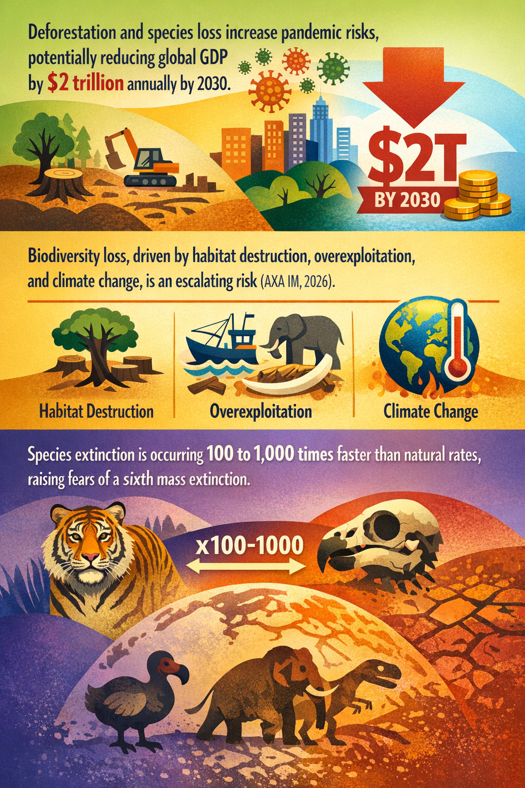
Prior to these developments, biodiversity loss was primarily framed as an environmental or scientific concern. However, recent financial and regulatory voices like AXA Investment Managers now identify biodiversity as a standalone and accelerating risk factor tied directly to corporate exposure through habitat destruction and overexploitation (Shaping Tomorrow 12/04/2026). This reshapes the traditional climate-centric view, positioning biodiversity integrity as a core dimension of operational risk and due diligence.
UK laws requiring companies to prove deforestation-free supply chains exemplify an operationalisation of biodiversity accountability by mandating transparency and traceability (Emperor Sustainability Briefing 02/07/2026). This introduces a new kind of systemic pressure: firms can no longer rely solely on high-level sustainability statements but must prove origin and impact at a detailed supply chain level, disrupting commodity markets long reliant on opaque sourcing.
Moreover, the ongoing sixth mass extinction crisis risk elevates the urgency of preventing further habitat degradation along supply chains, as current extinction rates outpace natural background rates by 100 to 1,000 times (DataDrivenInvestor 19/05/2024). This scientific backdrop is fueling investor and regulator attention towards systemic biodiversity-related risk exposure embedded in global trade.
The recurring theme is clear: biodiversity risk is becoming a supply chain transparency issue that transcends voluntary commitments. This change shifts biodiversity from an environmental externality to an embedded credit, regulatory, and reputational risk — inseparably linked to corporate sourcing practices and financial disclosures in a way not widely appreciated outside specialized regulatory or sustainability circles.
Disruption Pathway
The tightening of supply chain transparency rules could accelerate as technology advances, enabling real-time verification through satellite monitoring, blockchain, and AI audits. These capabilities would reduce the informational asymmetry that previously allowed deforestation and habitat destruction to persist undetected within complex supply networks.
This shift introduces stresses to existing commodity and agricultural value chains, where opaque, cost-driven sourcing models are prevalent. Firms unable or unwilling to meet traceability demands may face exclusion from markets, increased capital costs, or legal liabilities. Consequently, industries could adapt by investing directly in biodiversity-positive practices such as regenerative agriculture, sourcing certification infrastructure, and ecosystem service monetisation.
Feedback loops may emerge as ecosystem degradation linked to supply chain noncompliance intensifies regulatory scrutiny and investor risk aversion, which in turn incentivises greater transparency and stricter controls — potentially catalysing a tipping point in how biodiversity risk is priced and managed corporately.
If sustained, this dynamic could recalibrate dominant industrial and governance models from reactive conservation approaches to proactive, supply chain-embedded biodiversity stewardship integrated within corporate governance frameworks and financial risk management. Such a paradigm shift would place biodiversity on par with financial compliance and climate risk monitoring, fundamentally altering strategic positioning, investment flows, and regulatory oversight.
Why This Matters
Decision-makers should recognise this emerging supply chain transparency requirement as a lever that could reallocate capital away from firms failing to manage biodiversity risk effectively. This may force a repricing of assets and liabilities connected to land use, commodity agriculture, forestry, and natural resource extraction.
Regulators could see increased calls to expand and harmonise biodiversity-linked disclosure standards and due diligence laws, influencing global trade governance and compliance expectations. Early movers in adopting and integrating supply chain biodiversity verification technologies and practices may achieve a competitive advantage by reducing regulatory and reputational risks.
Supply chain disruptions or reconfiguration mandated by biodiversity proof requirements could reverberate across industrial structures dependent on natural inputs. Corporate boards and risk officers must therefore incorporate biodiversity loss trajectories and this transparency imperative into their strategic risk frameworks.
Implications
This signal could plausibly scale beyond niche sustainability efforts to drive structural change in risk governance, regulatory frameworks, and capital allocation within 5–10 years. It might catalyse a widespread shift in supply chain design and corporate environmental accountability norms.
However, it is not simply another voluntary environmental, social, and governance (ESG) trend or incremental compliance tick-box. The convergence of hard regulatory mandates, financial risk considerations, and biodiversity crisis urgency forms a distinct hybrid mechanism that could embed biodiversity metrics into mainstream commercial decision-making.
Competing views might argue that technology and compliance costs will delay adoption or that geopolitical resistance to supply chain scrutiny will fragment the ecosystem. Yet these do not negate the systemic push towards transparency but rather signal a more complex, uneven transition landscape.
Early Indicators to Monitor
- Expansion of legally mandated traceability and deforestation-free certification requirements in additional jurisdictions.
- Surge in enterprise adoption of blockchain, satellite monitoring, and AI tools for supply chain environmental auditing.
- Patterns of capital reallocation away from companies with opaque or high biodiversity impact supply chains.
- Incorporation of biodiversity-specific KPIs and disclosures in financial reporting and regulatory filings.
- Formation of international standards or consortia focused explicitly on biodiversity-related supply chain verification.
Disconfirming Signals
- Rollbacks or watering down of mandatory deforestation-free supply chain policies in key markets.
- Persistent technological or cost barriers preventing credible verification of supply chain biodiversity impacts.
- Major industry coalitions successfully lobbying for voluntary rather than mandatory biodiversity sourcing regimes.
- Significant geopolitical pushback fragmenting global harmonisation of biodiversity-related trade rules.
Strategic Questions
- How can firms integrate advanced supply chain transparency technologies to manage biodiversity risk proactively before regulation mandates?
- What regulatory cooperation or standardisation initiatives should governments pursue to avoid fragmentation and ensure effective biodiversity risk governance?
Keywords
Biodiversity; Supply Chain Transparency; Deforestation; Regulation; Capital Allocation; Ecosystem Services; Environmental Risk Management
Bibliography
- The UN Biodiversity Conference of Parties adopted at the COP 15 summit in 2022 the Kunming-Montreal Global Biodiversity Framework, which calls for countries to halt and reverse biodiversity loss by 2030 and to raise an additional $700 billion per year to do so. Bruegel. Published 15/12/2022.
- The current rate of species extinction is estimated to be 100 to 1,000 times higher than the natural background rate, prompting scientists to warn that the Earth may be on the brink of a sixth mass extinction. DataDrivenInvestor. Published 19/05/2024.
- Biodiversity loss, long overshadowed by more immediate climate concerns, is now increasingly recognized as an independent and accelerating risk driven by habitat destruction, overexploitation, and climate change itself (AXA IM, 2026). Shaping Tomorrow. Published 12/04/2026.
- UK companies will have to prove that procured items were produced without causing deforestation, which will require more robust oversight on their supply chains. Emperor Sustainability Briefing. Published 02/07/2026.
- Financial Industry analysis recognising biodiversity as an accelerating risk factor with implications for portfolio risk and investment strategies. Shaping Tomorrow. Published 12/04/2026.